A comprehensive map three years in the making is telling the story of humans' impact on the Great Lakes, identifying how "environmental stressors" stretching from Minnesota to Ontario are shaping the future of an ecosystem that contains 20 percent of the world's fresh water.
The results are published online in the Dec. 17 issue of Proceedings of the National Academy of Sciences. Co-author Ben Halpern, a researcher with UC Santa Barbara's National Center for Ecological Analysis and Synthesis (NCEAS), was a co-principal investigator in the expansive and detailed effort to map and cross-compare environmental stresses and the ecological services provided by the five lakes. The effort was led by researchers at the University of Michigan.
Their efforts have produced the most comprehensive map to date of Great Lakes stressors, and also the first map to explicitly account, in a quantitative way, for all major types of stressors on the lakes.
"This work represents the first time that two relatively new tools for resource management have been brought together –– mapping of the cumulative impact of human activities, and mapping of the provision of services to people from natural systems," said Halpern, who also directs UCSB's Center for Marine Assessment and Planning. "Each approach, by itself, offers a lot of insight into how to better manage and restore ecosystems and the benefits we derive from them; together, the approaches offer unprecedented opportunities."
"Despite clear societal dependence on the Great Lakes, their condition continues to be degraded by numerous environmental stressors," said David Allan, the project's lead researcher and a professor of aquatic sciences at the University of Michigan's School of Natural Resources and Environment. The map gives federal and regional officials an unprecedented scientific foundation upon which to sustainably manage the Great Lakes, the researchers conclude.
The environmental stress map was developed by a binational team of researchers from academia and environmental organizations, known as the Great Lakes Environmental Assessment and Mapping (GLEAM) project. The team drew upon the latest and best data from federal and state agencies, as well as non-governmental organizations and individual researchers.
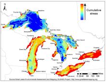
The map represents the combined influence of nearly three dozen individual stressors, and is incredibly detailed for a region spanning nearly 900 miles, showing impacts at the scale of half a mile. Thirty-four stressors were examined, including coastal development, pollutants transported by rivers from agricultural and urban land, fishing pressure, climate change, invasive species, and toxic chemicals. (The full list is at http://www.greatlakesmapping.org.)
To rank the relative importance of different stressors to ecosystem health, the team surveyed 161 researchers and natural resource managers from across the basin. Combining the mapping of multiple stressors with their ranking by experts to assess ecosystem health is an emerging new approach.
"Current efforts to conserve, manage and restore the Great Lakes often take a piecemeal approach, targeting threats one by one," Allan said. "We need to recognize that the Great Lakes are affected by multiple environmental stressors, and devise strategies based on a full reckoning."
Their work found high and low stress –– defined as human impacts such as physical, chemical, or biological disruptions that potentially have adverse effects on people, plants and animals –– in all five lakes. Ecosystem stress is highest in areas closer to shores, but also extends offshore in some parts. Large sub-regions of moderate to high cumulative stress were found in lakes Erie and Ontario, as well as in Saginaw and Green bays, and along Lake Michigan's shorelines. In contrast, extensive offshore areas of lakes Superior and Huron, where the coasts are less populated and developed, experience relatively low stress, according to the study.
The researchers launched a new website (http://www.greatlakesmapping.org) to share their results with policymakers, planners, and government officials in the region. The project will continue to acquire data to map stressors currently not included, and will regularly update the stress maps.
The Great Lakes Environmental Assessment and Mapping project began in 2009 with $500,000 from the Bloomfield Hills, Mich.-based Fred A. and Barbara M. Erb Family Foundation.
Related Links
Share this article
Related Stories