Watching Over the Whales


An online tool to detect and better protect — in near real-time — whales inhabiting the Santa Barbara Channel is now live. Whale Safe is the product of a collaboration among marine scientists with the Benioff Ocean Initiative at UC Santa Barbara and top whale researchers from across the country.
“We’re excited to finally launch it into the world,” said Morgan Visalli, a Benioff Ocean Initiative (BOI) scientist and Whale Safe project lead. The result of three years of work between BOI researchers and colleagues at Woods Hole Oceanographic Institution, Scripps Institution of Oceanography, Texas A&M University at Galveston, the University of Washington, UC Santa Cruz, and the National Oceanic and Atmospheric Administration’s (NOAA) Southwest Fisheries Science Center, Whale Safe is a mapping and analysis tool that displays near real-time data to help prevent ships and whales from colliding, an event that happens far too often off the West Coast.
“Unfortunately, 2018 and 2019 were the worst years on record for fatal whale-ship collisions off the coast of California,” Visalli said. “We hope that data from the Whale Safe system can help to reverse that trend.”
The high number of collisions is due to a confluence of several factors, she explained. For one thing, whales often feed, migrate, rest, mate and socialize in coastal areas. Blue whales, the largest animals that have ever lived, are currently found along our coast’s cold, krill-filled waters, which has been especially busy this summer. Aggregations of 30 blue whales were observed feeding in the Santa Barbara Channel in early August.
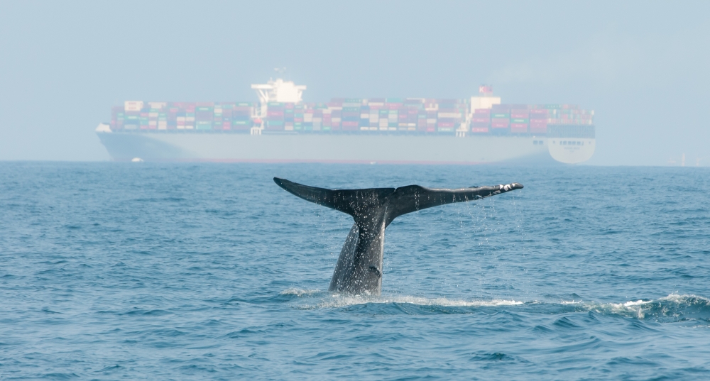
Unfortunately, the whales’ ancient migration paths overlap with some of the busiest shipping routes in the world, with cargo ships moving through the Santa Barbara Channel to and from the ports of Los Angeles and Long Beach. Marine shipping is an important industry to California and to the world, transporting an estimated 90% of global goods.
The vessels are enormous — often the size of skyscrapers and more than ten times the length of an adult blue whale. They tower so high above the surface of the ocean that whale spouts are difficult for ship captains to detect, let alone slow down for or avoid. Researchers estimate that more than 80 endangered blue, humpback and fin whales are killed by vessel collisions every year off the West Coast alone.
To help protect the endangered animals, the National Oceanic and Atmospheric Administration (NOAA) and partners have, since 2007, implemented voluntary speed reduction programs to slow ships down as they crowd into the channel with the whales. The program has a voluntary 10 knot (11.5 mph) speed limit for all large ships transiting through the important whale habitat in and around the Channel Islands National Marine Sanctuary. Research has shown that speed limits, when followed, appear to reduce the number of fatal collisions by 80-90% in some cases.
But while a slowly growing number of global shipping companies are participating in the voluntary program, more than half of ship transits in the Channel in 2019 still exceeded the requested 10 knot slow zone. It’s an amount the researchers hope will decrease as the Whale Safe monitoring system alerts users to the presence of whales in the area.
One of our goals is to provide real-time whale presence data that will help ships know when to slow down,” Visalli said. “In 2019, only 44% of the shipping industry followed the voluntary speed limit — we’d like to see that get closer to 100%.”
To help ships “see” the whales, the minds behind the Whale Safe tool brought together several technologies: an underwater acoustic system that automatically detects whale calls; near real-time forecasts of whale feeding grounds based on dynamic oceanographic data; and a mobile app used by community scientists to record whale sightings.
Developed and deployed by Woods Hole Oceanographic Institution scientists and engineers and monitored by Texas A&M Galveston scientists, the acoustic system consists of a hydrophone (underwater microphone) dropped into the Santa Barbara Channel that detects sounds in the water and processes them using an AI-powered computer providing identification of blue, humpback and fin whales in near real-time. The whale detections are then sent via satellite transmitter on the system’s surface buoy to scientists in Galveston for review and confirmation.
“I have spent decades recording blues and other baleen whales at different locations. In the past, we always had to go back and retrieve our instruments and data from the ocean floor to learn when the whales were present at our location, months or years earlier,” said Ana Širović, an associate professor at Texas A&M Galveston who is leading the analysis of acoustic buoy data. “It is really exciting to know that there are whales in the Channel now, within an hour or two of them making the vocalization.”
Meanwhile, real-time oceanographic data such as temperature and ocean currents are crunched by a model developed by researchers at the University of Washington, UC Santa Cruz, and NOAA to predict where and when blue whales are likely to be present within the area, producing information much like daily weather forecasts.
“Every day that I go outside, I look to see if it is raining and I check the weather forecast to see whether it is likely to rain,” said NOAA Research Ecologist and UCSC Adjunct Professor Elliott Hazen. “Our whale models can help mariners plan and make decisions as they approach our coast — today is cloudy with a chance of blue whales.”
“We’re harnessing the best and most current data to understand what habitats whales use in the ocean, and therefore where whales are most likely to be as their habitats shift on a daily basis,” said Briana Abrahms, an assistant professor at University of Washington who led the whale modeling effort. “The goal is to put this technology into the hands of managers, mariners and the public to help protect these animals from ship strikes and other human threats.”
Finally, community scientists aboard local whale watching and tourism boats add whale observations using the Whale Alert and Spotter Pro mobile apps. A program jointly run by NOAA’s Channel Islands Marine Sanctuary and Channel Islands National Park, the Channel Islands Naturalist Corps has collected and maintained one of the largest and longest-running datasets of marine mammal observations in Southern California.
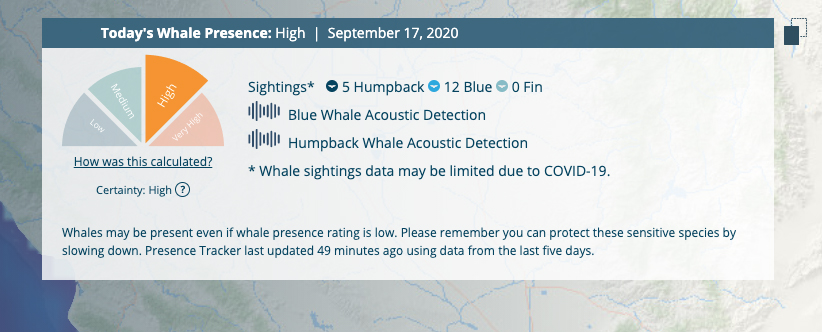
Together, these layers of information are combined into a daily Whale Presence Rating on the Whale Safe website — an indicator that describes the likelihood of whales from ‘low’ to ‘very high,’ much like a whale version of the Smokey the Bear fire danger rating.
“It provides a streamlined daily assessment of whale activity in the Channel,” Visalli said. “No one wants to hit a whale. No one wants to see coastal commerce interrupted. We hope that the data delivered by the new technology will provide ship captains with the information they need to protect whales while ensuring efficient maritime commerce.”
The tool tracks ships, too.
“Whale Safe also incorporates automatic identification system data, which is like GPS tracking data, but for ships,” Visalli added. Originally intended for ship collision avoidance and safety, the data can be picked up by boats as well as by transceivers on land or in satellites, and used to identify ships in the Channel and gauge their speeds. Whale Safe turns this information into “report cards” for the ships and their companies, rating their cooperation with voluntary speed limits in important whale habitat.
Whale Safe is one of several projects of the Benioff Ocean Initiative, an applied research center that endeavors to create replicable solutions to problems threatening ocean health. It was founded at UC Santa Barbara in 2016 with a $10M gift from Marc and Lynne Benioff.
“Some of the older blue whales have been swimming around out there since before the founding of UC Santa Barbara,” said Douglas McCauley, director of the Benioff Ocean Initiative and a professor in the Department of Ecology, Evolution and Marine Biology. “We are so thrilled today to put some cool new tech to work to make their ocean home a little safer.”
Success of Whale Safe will help create multiple benefits beyond saving endangered whates. When cargo ships slow down, they typically emit less CO2, create less noise pollution and release fewer NOx emissions which can cause cancer and affect lung health. In addition to their beauty, antiquity and ecological importance, whales are also massive living carbon storage devices. The International Monetary Fund estimates that one whale saved is worth thousands of trees when pulling carbon out of the atmosphere.
"Since the Industrial Revolution, pollution from human innovation has too often degraded our planet," Benioff said. "With Whale Safe, we'll harness the latest technology to help save the planet and some of the oldest mammals. This is a win, win, win — we save whales, fight climate change and make our air healthier. The world owes a profound debt of gratitude to the incredible team of researchers who turned this vision into reality."
Share this article
Related Stories


