Marine Census
They’re slipping on their wetsuits, charging their cameras and breaking out their seines — all for the good of the Pacific coast.
Joining more than 40 colleagues statewide, research scientists Jenny Dugan, Jenn Caselle, Robert Miller and Mark Page, of UC Santa Barbara’s Marine Science Institute (MSI), are embarking on multiple, multi-year research efforts to study the health and diversity of California’s Marine Protected Areas (MPAs). Funded to the tune of $9.5 million approved by the Ocean Protection Council (OPC) and administered in partnership with California Sea Grant and the California Department of Fish and Wildlife, the suite of statewide collaborative projects involves 24 institutions. It’s all part of the 2019 MPA Phase 2 Monitoring Program, aimed at evaluating the MPA network and whether it is meeting its goals of protecting and conserving the diverse marine habitats along the California coast.
“The Marine Protected Area is a spatial designation where there are added restrictions, usually for fishing,” said biologist Caselle, who herself is involved in four projects. Enacted through a 1999 piece of legislation then redesigned in 2011, the Marine Life Protection Act created the network of protected areas that today encompasses various marine habitats and zones. It has several levels of restrictions that generally limit taking marine life and other resources, so as to leave these areas and their denizens undisturbed. The goal of this wide variety of MPAs is to sustain biodiversity in the many and interconnected marine habitats — biodiversity that may have been impacted by fishing, recreation, pollution and other factors.
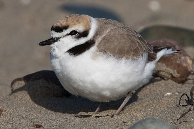
The snowy plover relies on healthy coastal ecosystems to feed and reproduce
Photo Credit: NATIONAL PARKS SERVICE
“It’s an ecosystem management device,” Caselle explained. “It doesn’t protect just one species of fish from one type of extraction — it protects the whole ecosystem.” In places where habitat is degraded or some species overfished, the restrictions give marine life a chance to regenerate. In other areas, MPAs may contain nurseries or spawning grounds, or reliable sources of food.
The design of the MPA network was an intense and often contentious collaboration with myriad stakeholders — people who use the coast and the water for work or play — weighing in with their opinions and concerns. But, say the scientists, MPAs aren’t just for the fish: If a protected area is healthy enough, it can supply fish to the places outside the MPA, which, in turn, ensures the livelihood of fishers in the area and charter boats that rely on sport fishing and underwater biodiversity for their livelihoods. The same could potentially go for kelp forests, which can export spores a few kilometers away from their home beds, potentially seeding new forests or replenishing ones that have been damaged by weather, fishing or invasive creatures.
“The more difficult questions the state of California is starting to ask is, ‘Can the MPAs buffer the effects of climate change in unique ways?’” said Caselle. The answer is difficult to come by, she added, but the effects of ocean warming have been apparent in recent years, by way of sea star wasting and kelp forest decimation.
Noted Dugan, “There is also this concept of resilience that a fully diverse ecosystem that supports species with intact natural population sizes and structures might have more capacity to recover from whatever climate change throws at it.”
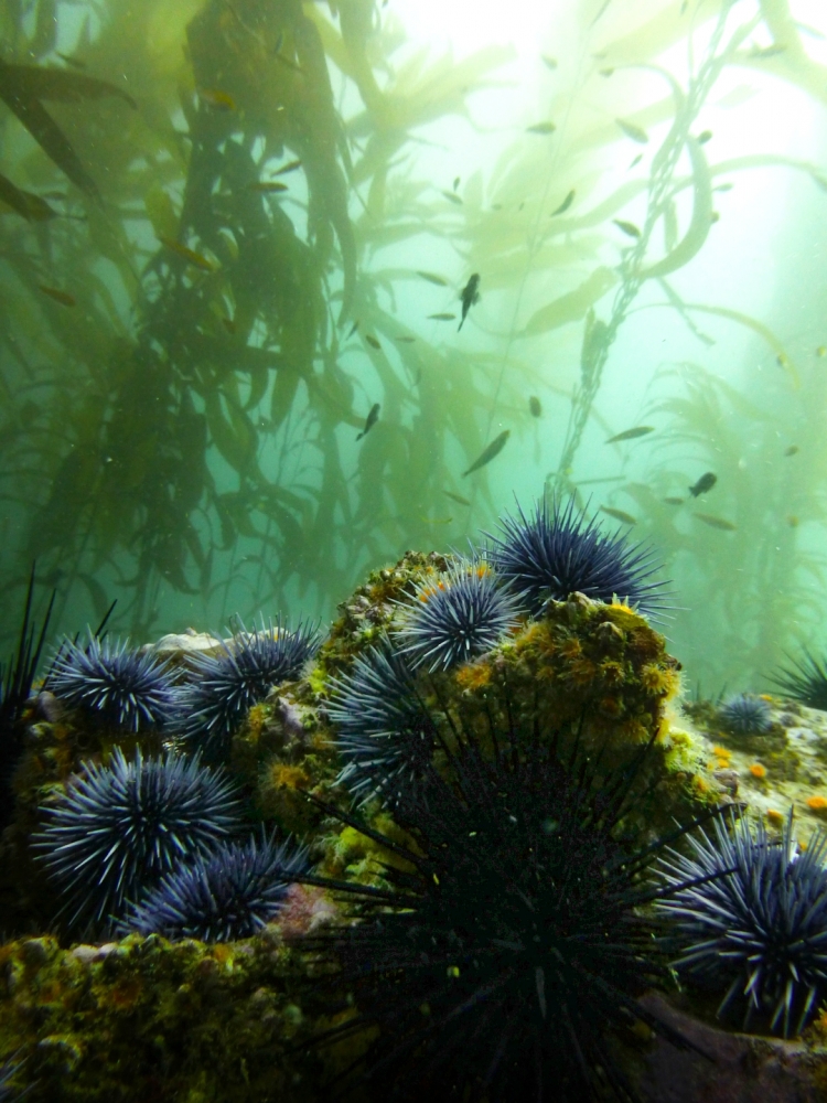
Left uncontrolled, urchins can demolish a kelp forest
Photo Credit: KATIE DAVIS/CASELLE LAB
Functional redundancy — the presence of more than one organism with the same role in a food web — is one way this can work, Dugan explained. If one species becomes threatened or even extirpated, others can rush in to fill its role — with functions that range from food for key animals to controlling the populations of other species — so the balance of the ecosystem is not tipped too far in one direction or another. In places where purple urchins had run rampant due to their sea star predators’ wasting sickness, for example, the presence of lobsters and California sheephead fish could keep urchin populations in check, which, in turn would keep the urchins from mowing down kelp beds and outcompeting the more desirable red urchins for food. Turns out, in areas where MPAs protected populations of lobster and sheephead — which are commercially and recreationally fished — purple urchin populations have not been as out of control and the kelp forests have been maintained.
These and other effects are among the things the scientists will attempt to capture as they build on and measure against data collected during several monitoring programs, including the MPA Baseline Monitoring Program, which ran from 2007-2018.
Healthy Forest, Healthy Beach
To begin to assess the effects of protecting marine biodiversity, marine biologist Dugan need go no farther than UC Santa Barbara. The Campus Point State Marine Conservation Area is a no-take zone that spans the beach from Campus Point across Isla Vista, to the Ellwood area in Goleta, then south into the water to cover 10.51 square miles of protected area. In addition to being a popular local surf spot, the area also encompasses Coal Oil Point Reserve, which is home to, among other creatures, the threatened Western Snowy Plover.
And what does the snowy plover — and other beach-dwelling nesting shorebirds — have to do with the ocean? Kelp forests.
“We found really compelling relationships between the amount of kelp on the beach, the number of invertebrates and the shorebirds that eat those invertebrates in our baseline studies statewide,” Dugan said. “Snowy plover chicks depend almost entirely on the tiny animals that eat the kelp that washes up on sandy beaches.” In fact, she contends, the more crustaceans and insects are available via kelp deposited on a nesting beach, the less the vulnerable beach-dwelling chicks will need to expose themselves to predators in order to get a meal. That, in turn, could help to boost their numbers.
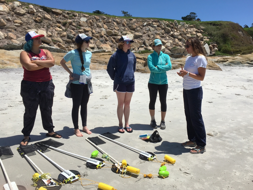
UCSB grad student Jessica Madden, right, trains fellow grad students from Moss Landing Marine Laboratory with the baited remote underwater video (BRUV) gear they will be using
Photo Credit: JENNY DUGAN
And it’s not just about the plovers. Dugan’s project, conducted alongside MSI co-PIs Page, Miller and 10 other researchers from seven institutions and their teams, will employ beach seines and use underwater video cameras at the shore to capture and count the fish dwelling in the surf zone, as well as conduct surveys of birds and stranded kelp. Additionally, the scientists will be measuring human uses and the physical characteristics of beach and surf zones. All these beach measures will be analyzed with the other data, such as kelp forest canopy biomass measured from space and the available baseline information from the different regions of the state.
Campus Point SMCA is only one of several California Marine Protected Areas where Dugan and team will be working in the course of their project.
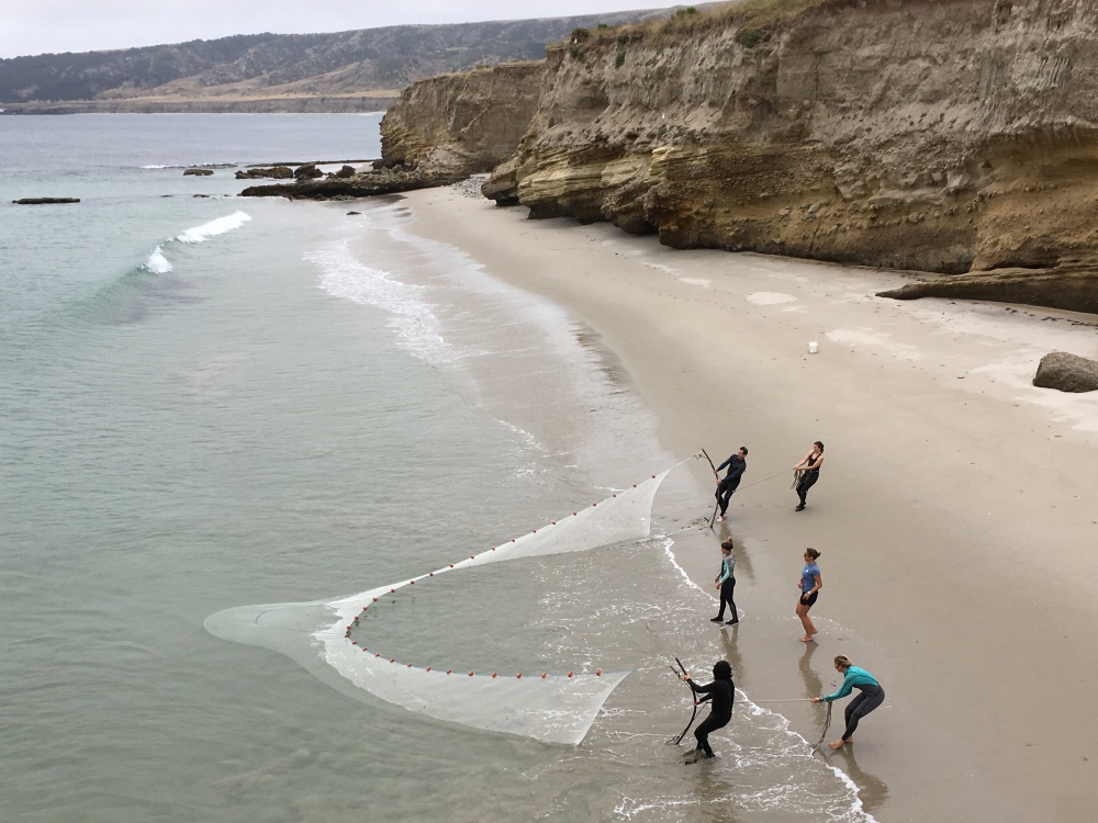
Dugan's team employs beach seines to get a sense of the fish of the surf zone
Photo Credit: JENNY DUGAN
“We’re going to be traveling up and down the state with our nets, wetsuits, cameras, clipboards and binoculars,” she said. The study area includes at least 21 MPAs from Humboldt to San Diego, each with their own distinct characteristics. Closer to home, Dugan and team will also be casting nets, counting birds and taking surf zone footage at Point Conception, Point Dume and Vandenberg State Marine Reserves. The data they capture will be used not only to compare against previous stats in the same areas, but also against data captured outside the protected areas to get a sense of their efficacy.
Underwater Life
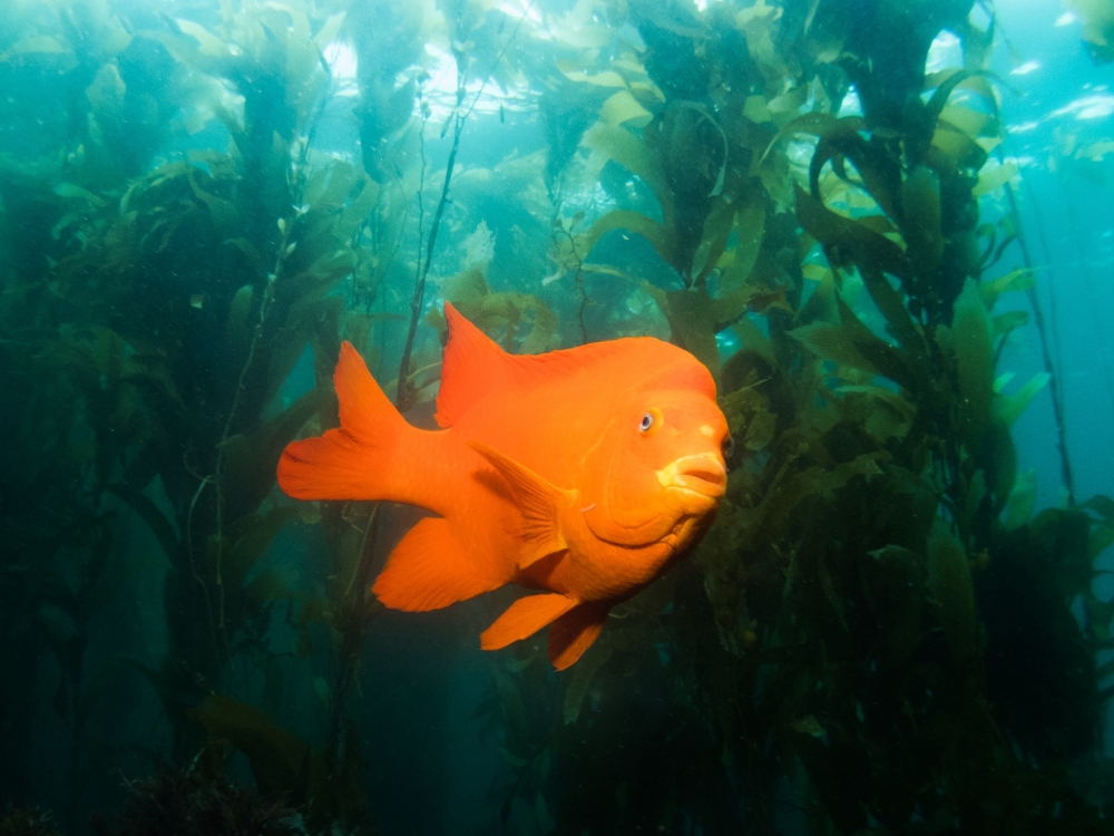
Caselle will be doing most of her work a little farther into the water. Along with her collaborators, which include teams of SCUBA-diving co-PIs and student researchers, volunteer fishermen, boat captains and charter companies, she will be monitoring the ecosystems from the rocky intertidal zone — the area between high and low tides — to nearshore kelp forests.
“Of all the different habitats, kelp forests and nearshore rocky reefs are the most subject to fishing,” Caselle said. “So they’re the ones that are most likely to show pretty extreme effects inside and outside the reserves.” The main questions her project seeks to answer, she said, are fairly straightforward: “Do we see a buildup of numbers and sizes of fish in the MPA as compared to outside areas? And if so, why?”
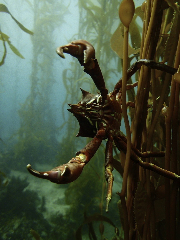
Kelp crab
Photo Credit: KATIE DAVIS/CASELLE LAB
Additionally, Caselle will consider the overarching MPA question of how removing fishing effects may have changed the food web and ecological networks. “Fishing usually takes out the bigger fish, which are usually the predators,” she said. “How does that trickle down through the whole food web? How does a healthy food web look compared to one where a lot of top fish predators have been removed? And do we see evidence of more resilience and rebounding?”
Seeking to answer these questions, Caselle and collaborators will visit the giant kelp forests along the Channel Islands National Marine Sanctuary and National Park, some of which are within the region that Caselle’s team has monitored for the past 20 years as part of the Partnership for Interdisciplinary Studies of Coastal Oceans (PISCO).
SCUBA diving will be the main tool for investigation in the kelp forests, as researchers collect data on the large algae which have recently been experiencing dramatic declines, resulting in impacts to local ecology and economy. The researchers also will collect canopy data via remote sensing and in situ instrumentation.
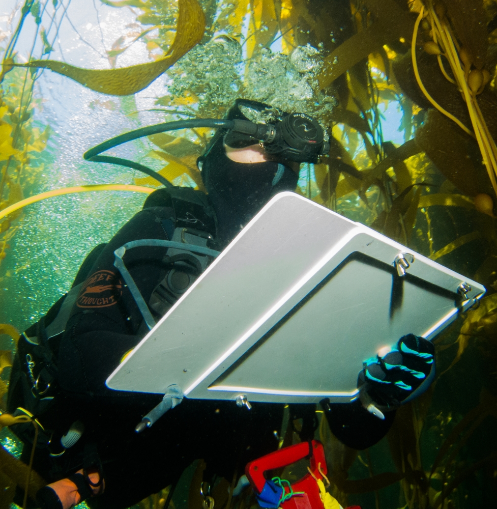
A diver collects data
Photo Credit: KATIE DAVIS/CASELLE LAB
In the deeper water, Caselle said, the teams will be using a combination of technology, including remote-operated vehicles and drop cameras that will allow the scientists to determine both location and size of the fish.
The scientists have another ace in the hole: volunteer anglers. The California Collaborative Fisheries Research Program employs the skills and expertise of some of the most significant — and often most critical — MPA stakeholders for some scientific fishing. The anglers will fish both inside and outside the protected areas, Caselle said, to sample the populations and see if and how fish “spill” from the MPAs to the surrounding zones.
“We keep very detailed data on everything that’s caught every minute,” Caselle said. “The fishing tackle is all standardized and we can calculate catch per unit effort from that, which is a metric of abundance.”
Caselle’s work, like Dugan’s, is not limited to the Santa Barbara portion of the Santa Barbara Channel; it will include a wide variety of MPAs ranging from northern to southern California.
The data collection and analyses from these rare, large-scale MPA monitoring projects, which are expected to take between two to and three years to complete, will feed into a statewide MPA network management review sometime in 2022, to be submitted to the California Fish and Wildlife Commission. From there the commission will determine the course of future MPA management.
More research stories from the Santa Barbara Channel can be found in The Current's featured compilation, Channel for Discovery.
Share this article
Related Stories


