A Bird’s-Eye Time Machine


Your computer screen looks like it’s afflicted with measles. A sprinkling of red dots cover a map of Orange County. Click on one of the dots and it’ll lead you to a black-and-white photo from 1938 of a vast, vaguely familiar landscape of what appears to be citrus orchards laid out in a nearly perfect grid.
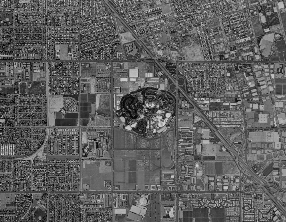
Click on another dot and up pops a similar photo, this one from April 1960. Housing tracks have mostly replaced the orchards and a freeway runs diagonally through the picture. But there’s something else different, a weird oblong shape in the middle. Zoom in and the unmistakable mosaic of Disneyland comes into view. There’s Tomorrowland next to the Matterhorn. To the west is Frontierland, at the bottom right, Adventureland.
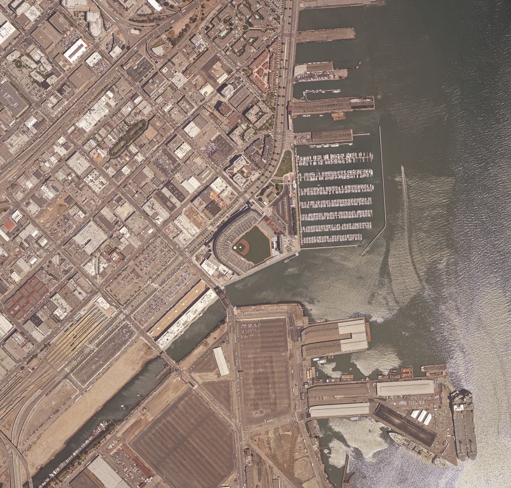
With another click you navigate 407 miles north and 89 years into the past. It’s San Francisco just a generation after the great fire of 1906, and in the lower right are a series of piers. Today the land just west of them is the site of Oracle Park, home of the San Francisco Giants.
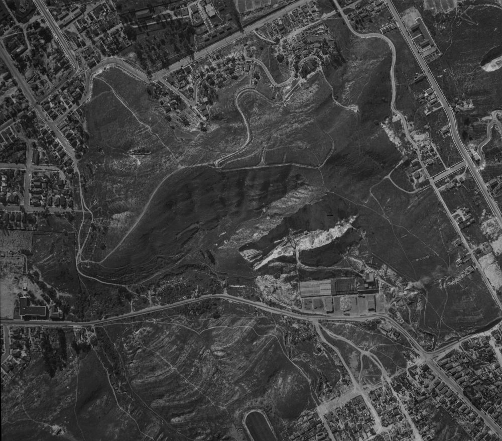
Not a Giants fan? Click again and you’re 380 miles south in 1931. The nondescript open space is Chavez Ravine. In 31 years Dodger Stadium will open on that land with the Los Angeles Dodgers losing to the Cincinnati Reds, 6-2.
“We can play this game for any place in California,” said Jon Jablonski, director of the UCSB Library’s Interdisciplinary Research Collaboratory and shepherd of the library’s Aerial Photography Collection. Depending on the location, he notes, “I can show you a picture once every five years, roughly, all the way back.”
World-Class Collection
Welcome to what Jablonski calls “the Google Earth time machine.” A vast repository of 2.5 million aerial photos, the collection is the largest in the world. Spanning from 1924 to 2010, the stockpile literally has California covered; about 90 percent of the collection is dedicated to the state.
And much of it is available to the public with the click of a mouse. More than 400,000 of the collection’s photos can be accessed through FrameFinder, an interactive database that allows you to search through time as well as geography. Photos that are already digitized can be downloaded free; the rest can be scanned for $20 each, plus a $10 processing fee to the entire order. A complete fee schedule is available here.
“And for the next person who wants to look at that photo, it’s free,” Jablonski said. “This is now how we’re building the digital collection. If you want something that hasn’t already been scanned, with one click you can request and pay for it. From then on, it’s free for every subsequent user, and those revenues help us to preserve the collection.”
A Valuable Resource
The photos, taken over the decades by dozens of aerial survey firms, were used primarily to make topographic maps, determine property lines, do land-use planning and more. Planes with large-format cameras generally flew north and south in a grid to create a high-resolution record of the area.
More than 99 percent of the photos provide a vertical, or straight down perspective; about 70,000 are oblique, bird’s-eye views, Jablonski said. And, since many of the vertical photos overlap, the digital images can be seen through virtual reality headsets in the library’s Interdisciplinary Research Collaboratory. Analong images with 60 percent overlap can be viewed with a stereoscope, available in the library’s Special Research Collections for a 3-dimensional effect. For questions about the collection, email special@library.ucsb.edu or call (805) 893-3062 or (805) 893-2779.
Today, as in the past, the main users of the aerial photo collections are developers, land-use officials, geologists and others whose living depends on accurate geographical imagery.
“All the local geologists know about this. All the local land-use planners and the guys at the county know about this,” said Jablonski, who noted its photos are frequently used to settle property line disputes.
“Every time someone needs to make a new subdivision or something, as part of their environmental due diligence they would have to document the historic use of the property,” he said. “That was the revenue stream. In the old days, just getting the photos might cost $300. We literally had contractors working in the library day after day putting the photos on photo copiers. That’s how it was done in the ’90s. And now we do this.”
The reconfigured database and FrameFinder went online in July 2017. “Right now with absolutely no publicity we know there’s about 90 visitors a day to that map,” Jablonski said. “And it’s been steadily rising. For the first couple of months there were about 40, and it’s been a steady climb since.”
Keeping It Cool
In an age when a lifetime of pictures can be saved on an external hard drive, 2.5 million photos might not seem like much. But when they’re large negatives and prints — many 9 by 9 inches — they require an extraordinary amount of space. The aerial photo collection is stored in at least three rooms in the library. Some of the most fragile film is stored in four refrigerators on Ward Drive just off campus. The library has upwards of 60,000 images stored in a high-tech vault near Magic Mountain that holds film and television archives on extremely flammable nitrate film.
The images are stored in refrigerators because of what’s known as “the vinegar syndrome.” As the acetate film breaks down it releases acetic acid and begins to smell like vinegar. Unfortunately, the aroma is a death sentence for the film because the deterioration can’t be reversed — only slowed by low temperatures.
The refrigerators on Ward Drive are the same ones used to grow mosquitoes for West Nile virus research, Jablonski said. “We’re keeping old black and white film cold because it’s beyond its lifespan. I know if it was at room temperature, sometime in the next six to 18 months it would fall apart. It needs to be kept around 40 degrees Fahrenheit.”
Which means Jablonski is in a race to get the film digitized as quickly as possible.
“We have film that’s deteriorating,” he said, “so the end goal is to raise enough attention about this resource and have more people come in and request scans. Then we can use that revenue to buy more cold storage and maybe take a whole swath of photos that are starting to disintegrate and scan all of those. It’s way cheaper to hand a giant pile to a contractor and say, ‘Scan all of these,’ than it is to scan two or three a day for customers.”
The Future Calls
Jablonski estimates he can keep the more modern film relatively stable for 50 to 75 years — about as long as it’ll take to scan everything. It’s an ambitious undertaking, he acknowledged, but a necessary one.
“Can you imagine what the world’s going to look like in 50 or 75 years?” he asked. “I can’t. But I know people are still going to want this information.”
Besides, the collection is more than a bunch of photos, he said. It’s a treasure trove of time and space, a record of a state always in motion, ever changing.
“We’re the only place that has these things, and we get the film that was in the cameras when the plane was flying over the landscape,” Jablonski said. “It’s a part of the history of California and it’s a visual representation of what the landscape looked like at the time. We can’t send an airplane back in time to make new photos. This is what we have.”
Share this article


