Conservation Sea Change

Beyond the breakers, the ocean is like the Wild West. While not completely lawless, its vastness and remoteness make it hard to observe and more difficult to manage human activity.
Recently developed technology may change that. A navigational safety aid called AIS (Automatic Ship Identification Systems) — which transmits publically accessible data on the exact position of ocean-going vessels via satellite — is not only useful for collision avoidance, but also has potential as a means of protecting ocean health. An international group of scientists explored exactly how the power of this information could be harnessed to intelligently manage sustainable futures for fish and fishermen across global oceans.
UC Santa Barbara’s Douglas McCauley led the team that analyzed billions of vessel data points to answer two important questions: Is a new cohort of massive marine parks doing its job to stop illegal fishing? And can this data help back a planned United Nations treaty to better manage high seas biodiversity? Their results appear in the journal Science.
“The oceans are home to our planet’s most spectacular wildlife, healthiest food and treasured ecosystems,” said McCauley, an assistant professor in the Department of Ecology, Evolution, and Marine Biology. “We need a new generation of smart observation tools to carefully manage the future of the ocean.”
In the past five years, recognition of the diverse values of the ocean has fueled explosive global interest in setting up gigantic ocean parks, but little attention has been paid to how to protect them. In 2015, more of the ocean was protected in these massive parks than ever before.
“These new parks will be a game-changer for the oceans,” McCauley said, “but only if they do what they promise.” He contends that the new mega-park boundaries are too big to be enforced by boat or plane, but suggests that satellite observation could provide a solution.
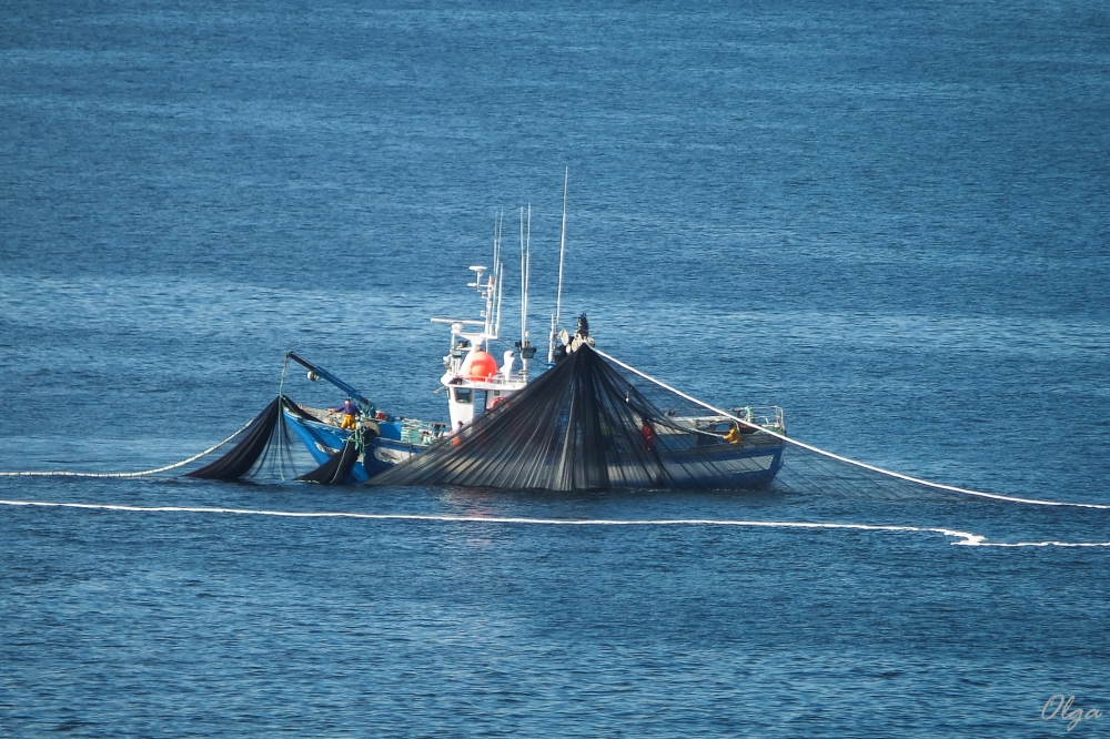
So the researchers took satellite-sourced AIS data for a test drive. They watched from thousands of miles away as Kiribati, one of the world’s poorest countries, closed the waters around the Phoenix Islands to fishing on Jan. 1, 2015. Almost all fishing boats vacated this California-sized protected area right before it closed. One exception was reported to Kiribati, and officials interdicted and fined the vessel.
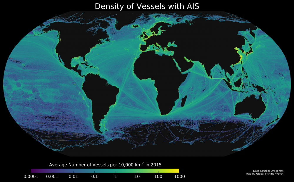
Last year, the United Nations committed to drawing up a new treaty to manage biodiversity in the 64 percent of global oceans in international waters. McCauley’s team mapped out human use of the high seas in marine areas that lie beyond national boundaries, creating the world’s first view of satellite-tracked fishing activity in the Pacific.
According to McCauley, the value of AIS data extends well beyond keeping track of where fishing takes place. He noted that this same data can be used to reduce collisions between whales and ships, to intelligently zone the ocean to keep wildlife safe and marine commerce flourishing, and to monitor the launch of seabed mining operations.
“Determining what is going on out there has previously been like assembling a puzzle in the dark,” McCauley said. “But with this new data, it’s like someone suddenly turned on the lights.”
Nonetheless, the vessel-tracking data has its weaknesses. “The data is only as strong as the policy that backs it up,” McCauley said. “Not enough vessels are using AIS transponders and nobody observes whether they are kept on and used properly.”
The investigators argue that this poses a double threat to public safety and the environment. “We wouldn’t allow airplane pilots to decide whether or not they keep their tracking systems on when landing at busy airports,” said McCauley, who pointed out that most of the loopholes in this system could be closed with policy reform.
“For decades, we have been tracking other species — from seabirds to sharks — but now for the first time, we can understand our own ecology, and how and where we impact the oceans on a global scale,” said co-author Boris Worm of Dalhousie University in Halifax, Nova Scotia. “This is revolutionary information, both from a scientific and policy perspective.”
The authors of the paper want to put the power of this new data in everyone’s hands. To make that happen, a group called Global Fishing Watch aims to launch a tool that will allow anyone to make free use of AIS data on fishing.
McCauley suggests that in an increasingly crowded world, it is healthy and necessary to embrace smart tech like AIS. “With tools such as this, we stand a real chance of stopping activities that steal food and biodiversity from poor nations, of curbing social injustice at sea and of cooperatively managing a healthy future for our oceans,” he said.
Share this article
Related Stories


