High-Resolution Satellite Images Now Available to Universities Via New Public-Private Partnership
A major boost to U. S. university research using satellite imagery has occurred in Santa Barbara, through a public-private partnership.
Academic researchers can now scan the U.S. and Canada via a newly-available, high-resolution satellite image catalogue, thanks to a partnership between the University of California, Santa Barbara and Terra Image USA, a private company based in Santa Barbara.
These images were previously prohibitively expensive, costing from $2,400 to $7,800 per digital scene. Detail as small as a tree can be viewed in these images.
The collaboration between UCSB and Terra Image USA is breaking down the barriers to the academic use of commercial satellite imagery, cutting the cost by nearly 90 percent.
"This is a critical time of global change when we need every opportunity to observe, understand, and appropriately respond to the changes that are occurring," said David Siegel, professor of geography and director of UCSB's Institute for Computational Earth System Science (ICESS), the lead university institute involved in the partnership.
"Use of the new data will aid U.S. researchers tremendously in these efforts."
Siegel expects many universities will take advantage of this new research resource. Researchers can now track changes in land use and land cover, vegetation -- including wetlands, forests, and agriculture -- urban change, transportation, water resources, mineral resources, geomorphology changes, plate tectonics, coastal resources, and much more. "If a volcano erupts or a fire starts, we can request that a satellite be tasked to collect images of that event," said Siegel. Besides current satellite images, researchers can access a rich archive of historical images dating back to 1986.
The images are collected by a constellation of French satellites called "SPOT," an acronym for "Satellite Pour l'Observation de la Terre," meaning satellite for Earth observation. UCSB and Terra Image USA entered into a research partnership on June 20, 2005, which gave more than 40 UCSB faculty members, and many more of their students, virtually unlimited access to high spatial resolution SPOT satellite imagery across the U.S. and Canada, a research asset that had previously been available to universities in only very limited quantities.
On December 1, 2006, UCSB and Terra Image USA signed an agreement to dramatically expand the size and scope of their research partnership. Terra Image USA, in collaboration with UCSB, is offering all U.S. universities a special, subscription-only service that provides unprecedented pricing for archived and programmed SPOT imagery for academic research purposes. In support of this agreement, Terra Image USA has delivered SPOT satellite imagery with a retail value of over $100 million to UCSB, all of which is available to the university for research purposes.
Using the data, UCSB has created an online, searchable catalogue for the imagery. UCSB is also digitizing and hosting the images to facilitate use by researchers at UCSB and other institutions. This work is based on many years of research at UCSB in digital library technology.
"Access to this imagery has opened whole new frontiers of research for us here at UCSB, explained Siegel. "The investment that's been required to catalogue and digitize the imagery has been significant, but well worth it. We're gratified that this work will enable other universities to access this valuable asset. Use of SPOT data will aid U.S. researchers tremendously in their efforts to understand global change."
Mike Hopkins, chief executive officer of Terra Image USA, said, "We have been pleased with the results of the original research partnership with UCSB and are excited to be entering this next phase which is intended to eliminate the historical barriers to the research use of SPOT satellite imagery."
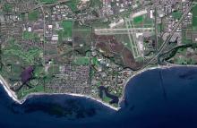
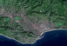
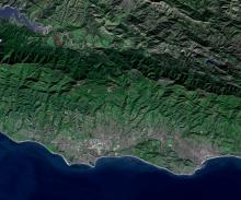
† About the Illustrations
Images taken by the SPOT 5 satellite on December 25, 2004.
Images are 2.5m resolution natural color display of SPOT 5 imagery (Copyright CNES 2004, distributed by Terra Image USA.)
Related Links
Institute for Computational Earth System Science
Terra Image USA
Share this article
Related Stories